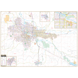
The Eugene - Springfield, Oregon Wall Map by Kappa Map Group measures 63? W x 48 ? H (5'4" W x 4'H) and is in complete street detail at a scale of 1? = 2,000 feet. Provides up-to-date cartography with new streets and changes. Printed in color with a markable and washable, laminated surface. Streets indexed in a separate book. Mounted top and bottom with hanging rails.
Area of coverage: North: all of the City of Coburg; South: to include all of the city of Creswell and Lowell; East: all of the city of Springfield and Lowell; West: to include Mahlon Sweet Field (Eugene Airport).
Includes airports, all streets and highways, government buildings, cemeteries, shopping centers, fire and police, hospitals, water features, educational facilities, railroads, recreational parks, golf courses and country clubs, post offices, ZIP code numbers and boundaries, township names, city limits (color coded), and points of interest.
Railed wall maps can be turned into pull down maps on spring rollers for an additional $30.
Year: 2013
Edition: 1st
These maps are printed and finished to order. Please allow 4-6 weeks for delivery.